
The National Oceanic and Atmospheric Administration (NOAA) announced the availability of new, high-resolution land cover data—used to document key geographic and landscape features covering Earth’s surface—for coastal communities across the country, including the Great Lakes.
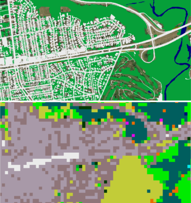
For more than two decades, NOAA’s Office for Coastal Management has been producing consistent, accurate 30-meter land cover and change information through its Coastal Change Analysis Program (C-CAP). Thanks to funding from the GLRI and Bipartisan Infrastructure Law, new 1-meter land cover data are now available for the coastal United States, including the Great Lakes.
Initial high-resolution land cover products, released in January 2024, include three feature layers—impervious surfaces, tree canopy, and water features. By providing more detail (900 times that of the 30-meter regional land cover), these new land cover data sets support a wide range of local and site-level applications that are critical for climate adaptation and resilience planning.
NOAA’s longer-term goal is to build upon these initial data products to develop a full C-CAP classification scheme (with up to 25 classes, including wetlands) for all coastal areas by the end of 2025, with updates envisioned every four to six years. This expanded mapping is currently under development for Green Bay, Wisconsin, and the Lake Superior National Estuarine Research Reserve and is expected to be released later this summer. Additional mapping for the Great Lakes will continue to leverage GLRI funds.
Visit the C-CAP High-Resolution Land Cover web page on NOAA’s Digital Coast to download these new data and view additional information, including a story map and handout. For any questions or technical assistance needs, please contact the C-CAP lead, Nate Herold (nate.herold@noaa.gov), and the Great Lakes regional geospatial staff, Brandon Krumwiede (brandon.krumwiede@noaa.gov) and Lara O’Brien (lara.obrien@noaa.gov).