
When oil or chemicals spill in the Great Lakes, responders need accurate and detailed information on the natural and human resources that might be affected. The entire region depends on healthy and safe lakes, and any size spill can have serious consequences. The GLRI has invested heavily in restoration efforts around the lakes, working to protect clean water, wildlife, and vital habitat. To help safeguard this important work, GLRI recently partnered with NOAA’s Office of Response and Restoration to begin updating Environmental Sensitivity Index (ESI) maps and data for the region. ESI datasets compile information on the sensitivity of different shoreline types, biological resources like plants and animals, and human-use resources such as parks and marinas.
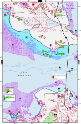
A recent spill shows the critical importance of spill preparation and the benefits of updated ESI data. On June 9, 2022, 5,300 gallons of gear oil from Algoma Steel in Sault Ste. Marie, Ontario, spilled into the St. Marys River and closed the Soo Locks for three hours, shutting down this key shipping corridor. New ESI data, updated in 2021 with funding from the US Coast Guard (USCG), were available for query by the USCG through NOAA’s Environmental Response Management Application (ERMA(R)), providing information regarding use of the spill area by state listed threatened and endangered bird and fish species including the Common Loon, Common Tern, Peregrine Falcon, Cisco and Lake Sturgeon, which are listed as potentially spawning in the area during the months of May to July. The same query provided information about the wetlands, gravel beaches, and armored shorelines at risk down river of the spill. The oil from this spill was deemed unrecoverable, and the response was limited to the placement of oil booms at the head of the Soo Locks and across the river downstream of the locks. No shoreline or wildlife impacts were observed.
NOAA is on an accelerated schedule to update Great Lakes ESI datasets so that new maps will be available in the event they may be needed to quickly support future spill responses. GLRI is supporting an update to the Lake Ontario dataset that is expected to be complete by December 2023. The new data will also be available to help states, tribes, and local partners better identify, protect, and restore coastal habitats.