
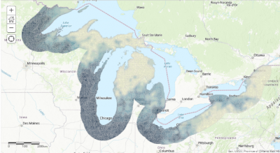
Every spring and fall, millions of birds and bats migrate through the Great Lakes region as they travel between their wintering and breeding grounds. With GLRI funding, the U.S. Fish and Wildlife Service (FWS) studied bird and bat activity using avian radar and acoustic monitors respectively. This activity is now mapped as bird and bat concentration areas in the Great Lakes basin! These maps can help inform conservation and are found in The Great Lakes Airspace Map Decision Support Tool (DST).
FWS is now excited to share a new Story Map about the Great Lakes Airspace Map Decision Support Tool and their new Avian Radar Project website where you can find a link to the Great Lakes Airspace Map DST and a user's guide on the website, along with project reports and data.
This tool is an outgrowth of FWS’s GLRI project that characterized migration of birds and bats around and over the Great Lakes. The purpose of the tool is to provide information on the relative use of airspace along Great Lakes shorelines to help identify priority habitat for protection and restoration and to better integrate migratory bird and bat conservation efforts into on-the-ground conservation projects.
Let FWS know if you've used the tool and how it worked! (Jennifer_white@fws.gov)