
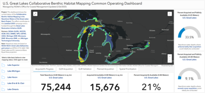
Announcing the release of the U.S. Great Lakes Collaborative Benthic Habitat Mapping Common Operating Dashboard. This new tool shows the current status of high-resolution bathymetry data, validation data collection, and benthic habitat mapping for the nearshore waters of the Great Lakes Basin. Bathymetry data is the measurement of water depths and provides essential information for protecting the region’s vital freshwater resources and aquatic habitat, identifying critical underwater infrastructure, and improving navigational safety.
The dashboard was developed to support the Collaborative Benthic Habitat Mapping in the Nearshore Waters of the Great Lakes Basin Project, a multiyear, multiagency project funded through the Great Lakes Restoration Initiative (GLRI) under Focus Area IV. The project addresses critical bathymetry and benthic habitat data gaps for the nearshore waters of the U.S. Great Lakes through the collection of new measurements using light detection and ranging (lidar) collected on board of aircraft, sound navigation and ranging (sonar) collected on board of vessels, and high-density benthic habitat classification mapping products to inform habitat restoration and natural resources management in the region. This effort also contributes to Lakebed 2030, a regional campaign seeking to make high-resolution bathymetry data available for the entirety of the Great Lakes by 2030.
Contacts: Lara O’Brien (lara.obrien@noaa.gov) and Brandon Krumwiede (brandon.krumwiede@noaa.gov)